
The Interstate Highway System is one of the, if not the, most important infrastructure projects in the United States, and it forms the backbone of the country’s transportation network. It consists of 70 primary and 323 auxiliary routes spanning over 48,000 miles of asphalt road and accounts for one-fourth of all vehicle miles driven. It is estimated that, since the network’s inception in 1956, it has fueled U.S. gross domestic product growth by 340%. Despite the network being declared complete in 1992, there are still plans to expand the network. This post discusses some of these expansion plans.
I’ve been very vocal about the need to pursue major transit infrastructure projects in U.S. cities and the need for an intercity rail network. However, there are definitely times when highways have their place, and that is especially true in sparsely-populated, rural areas. Good highways are especially important to the trucking industry — which, by and far, move the most freight in North America. They are also essential in connecting the country and making far-flung places closer to job centers and urban areas. This in turn helps with the development of those areas.
As America’s cities grow and living patterns shift, it necessitates for the original 1956 Interstate plan to be revised. Routes that were once rarely used might now have become major arteries, and it is crucial that the Interstate network be able to adapt to growth in areas that were often overlooked in the original plan, notably in the West and South. These are also the areas where most of the proposed Interstate routes or major extensions are planned to be located.
Interstate 3
The Interstate 3 corridor is a proposed highway that will connect the cities of Savannah, Ga., and Knoxville, Tenn., along the Savannah River. The highway is still in its early stages, but cities that the highway will serve likely will include Greenville, S.C., and Augusta, Ga., or Columbia, S.C.

The Federal Highway Administration has proposed four different routes for I-3 to follow, while three alternative routes are shown from a public study, dating back to 2010. Of these choices, Corridor C would run past the two biggest cities if a straight line were to be drawn between Knoxville and Savannah.
I-3 would create a new route roughly paralleling Interstates 75 and 26 and, if chosen to pass through Augusta, would give the city a new north-south freeway. However, considerable barriers to the construction of this highway exist. Notably, any highway running directly south of Knoxville would require constructing a road through the Appalachian Mountains in the Nantahala or Chattahoochee National Forests. Such a project would likely be extremely costly and environmentally destructive.
Interstate 9
Many of the largest cities not currently served by an Interstate Highway are located in California’s Central Valley area. This includes Fresno, with over 525,000 people, Bakersfield, with 378,000 people, Modesto, with 212,000 people, and Merced, with 83,000 people. The reason for this is because Interstate 5, the West Coast’s major north-south arterial highway, was chosen to bypass the whole Central Valley to avoid upgrading California State Route 99, the freeway serving the region.
SR 99, which mostly follows the route of the now-decommissioned U.S. Route 99, is the only north-south highway in the Central Valley. The Central Valley section of the route has been upgraded to a four-lane freeway in many sections, owing to increased traffic passing through the area.
However, with the area’s booming population and traffic along SR 99 getting worse, there has been growing talk to bring the most of SR 99, specifically the section between Sacramento and the I-5/SR 99 junction south of Bakersfield into full compliance with Interstate Highway Standards. The new route would be named Interstate 9 (or Interstate 7).
Doing so would require substantial work: bridges not meeting Interstate clearances would have to be rebuilt or relocated, shoulders would have to be added, medians would have to be widened, and noncompliant interchanges would have to be rebuilt.

Upgrading SR 99 would have clear benefits to California as a whole, not just the Central Valley. It would provide an alternative freeway connecting the northern and southern parts of the state, helping alleviate traffic on I-5 and U.S. Route 101, the other major north-south highway in California. It would also improve accessibility to the Yosemite and Sequoia National Parks and spur economic growth in the area.
Interstate 11
The opening of a 22-mile stretch of Interstate 11 in Nevada in 2017 created America’s newest Interstate Highway. The highway starts in Henderson, Nev., just south of Las Vegas, and travels south, bypassing Boulder City and crossing over the Callaghan-Tillman Memorial Bridge across Hoover Dam. The Interstate ends just beyond the Arizona state line. It was formed after the Boulder City Bypass was constructed, rerouting U.S. Routes 93 and 95 onto the new freeway. This new road helped to greatly alleviate congestion in the small town of Boulder City, where drivers on the old road had to make a left turn in the downtown area, often causing massive backups.
I-11 is currently being extended to the Phoenix area. When complete, it will connect Las Vegas and Phoenix, the two biggest cities in America not currently directly connected by an Interstate highway. (Instead, drivers must use Route 93, which is still not a freeway in some places.) There are also plans to further extend the highway north to Reno, Nev., from Las Vegas, which would create a new north-south Interstate highway east of the Sierra Nevada. This would be done by upgrading Routes 93 and 95 to Interstate standards.

Arguably, the I-11 corridor project is the most important highway construction project on this list. Not only will it connect the fifth and 25th largest cities together with a direct freeway, but it will also help form a triangle of highways between Los Angeles, Las Vegas, and Phoenix and possibly be the start of an all-new north-south artery stretching from the Mexican to the Canadian borders.
A more in-depth post on I-11 is planned for this blog; stay tuned to make sure you don’t miss it.
Interstate 14
Interstate 14 currently exists as a 25-mile-long freeway in Texas, connecting the cities of Temple and Killeen. The route is proposed to be extended both east and west. The road is envisioned to stretch as far west as El Paso, Texas, and as far east as Augusta, Georgia. The highway would create a new road stretching across central Texas and serve cities such as College Station, Texas; Alexandria, La.; Meridian, Miss.; Selma and Montgomery, Ala.; and Columbus and Macon, Ga. Designated as the Gulf Coast Strategic Highway, it was included in the Bipartisan Infrastructure Bill that passed late last year and could be constructed in the foreseeable future, being defined as a high-priority corridor.
Such a route would be strategic, as it would connect up many air force bases, Gulf Coast ports, and several major southern cities lacking Interstates.

The route would also run through some of the most impoverished parts of the country in the South, and a highway would provide more opportunities to those living there. As the area has a significant Black population, it would also help bring more economic development to majority-Black areas.
In addition, it is also proposed for I-14 to have an auxiliary highway serving as a beltway around College Station and Bryan, an area that has seen significant growth in recent years. Constructing I-14 would also give drivers a choice to drive across Texas without needing to go through Dallas or Houston, areas commonly prone to traffic jams.
Interstate 42
Like some of the routes discussed previously, Interstate 42 would consist of upgrading a currently-existing highway to Interstate freeway standards. Specifically, the I-42 corridor would follow U.S. Route 70 in North Carolina for 137 miles from Garner, N.C. (just south of Raleigh) down to the Atlantic coast at Morehead City, N.C.
The Interstate would take over Route 70 as a major hurricane evacuation route and freight transportation route. It was designated a high-priority corridor in the Fixing America’s Surface Transportation Act of 2015.

Interstate 69
Interstate 69 can be said to be one of the most fragmented highways that exist in the country right now. It currently consists of 10 disjointed segments that stretch all the way from Port Huron, Mich., near the Canadian border, down to Brownsville, Texas. Other segments exist in Mississippi, Tennessee, Kentucky, and Indiana.
When completed, the highway will stretch from its current terminal in Michigan down to south Texas, with a split in Victoria, Texas, that will allow the highway to serve McAllen, Laredo, and Brownsville, Texas, all connecting to the Mexican border.

The alignment of the route passes through many major metropolitan areas. They include Brownsville (130th largest metropolitan area); McAllen (65th), Laredo (167th); Houston (fifth); Shreveport, La. (140th); Memphis (43rd); Indianapolis (33rd); Fort Wayne, Ind. (133rd), and Lansing, Mich. (106th). It will also pass near many other major cities, all of which will be able to take advantage of the new corridor.
The largest benefit to building I-69 is that it will help greatly facilitate trade between Canada and Mexico under the U.S.-Mexico-Canada Agreement, which replaced the North American Free Trade Agreement, or NAFTA, in 2020. It will also help better connect multiple the central South with the Interstate highway network, as many cities currently only have one or two Interstate connections.
Progress on the highway has been slow in recent years, however, owing to a lack of funding. Indiana expects to finish its section of I-69 by 2024.
Interstate 73
Yet another proposed north-south Interstate highway is I-73, which is proposed to run from Myrtle Beach, S.C., to Sault Ste. Marie, Mich., following a northwest-southeast alignment. The proposed route will serve Michigan, Ohio, West Virginia, Kentucky, Virginia, and North Carolina, passing through the major cities of Columbia, S.C.; Roanoke, Va.; Blacksburg, Va.; Huntington, W.Va.; Columbus, Ohio; Toledo, Ohio; and Lansing, Mich.
The alignment would make it one of the few Interstate highways to directly cross the Appalachian Mountains in southwestern Virginia and West Virginia. It would help provide better connectivity to one of America’s poorest regions.
I-73 currently only exists as a 100-mile stretch in North Carolina, running from just north of Greensboro to Ellerby, though the section between Asheboro and Ellerby is concurrent with I-74.

However, Michigan and Ohio have suspended plans to continue pursuing the highway, instead choosing to redirect funds to other highway projects, so the chances of a fully-completed I-73 in the near future are slim.
Interstate 99
Interstate 99 currently exists as two disjointed segments: a 13-mile chunk in upstate New York from the Pennsylvania state line to a junction with I-86, U.S. Route 15, and New York Route 17 in Corning, N.Y. The southern segment starts in Bedford, Pa., off a junction from I-70/Pennsylvania Turnpike and runs north to meet I-80 near Bellefonte, Pa.
The route currently runs through State College, Pa., the home of the sprawling flagship campus of Pennsylvania State University in University Park. The other sizable urban area the freeway will run through is Williamsport, Pa., which has a metro area population of 114,000.
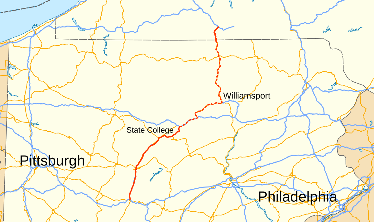
The highway is the only Interstate freeway to run north-south between Scranton, Pa., where I-81 runs north to Binghamton and Syracuse, N.Y., and Erie, Pa., where I-90 runs north to Buffalo. An Interstate passing through the region would provide an alternative for travelers from Philadelphia, Pittsburgh, or Harrisburg traveling north. It would also be conveniently located for drivers coming from Washington, D.C., or Baltimore to use to travel to Upstate New York.
Most of U.S. Route 15, which closes the gap between the two disjointed parts of I-99, has been upgraded to Interstate standards. Work is still ongoing, and there are plans from the Pennsylvania Department of Transportation to fully close the gap by 2026.